

• Biodiversity
    • Why is Biodiversity Important?
    • Threats to Biodiversity
    • What are Species at Risk?
    • Recovery Planning
    • Environmental Monitoring
  • Species at Risk
    • Species at Risk
      • SAR in the Sydenham
      • Mussels
      • Fishes
      • Snakes
      • Turtles
    • Mussels
      • Eastern Pondmussel
      • Fawnsfoot
      • Kidneyshell
      • Lilliput
      • Mapleleaf
      • Northern Riffleshell
      • Purple Wartyback
      • Rainbow
      • Rayed Bean
      • Round Hickorynut
      • Round Pigtoe
      • Salamander Mussel
      • Snuffbox
      • Threehorn Wartyback
      • Wavy-rayed Lampmussel
    • Fishes
      • Blackstripe Topminnow
      • Eastern Sand Darter
      • Grass Pickerel
      • Northern Madtom
      • Northern Sunfish
      • Pugnose Minnow
      • Pugnose Shiner
      • River Darter
      • Silver Lamprey
      • Spotted Sucker
    • Snakes
      • Eastern Foxsnake
      • Eastern Hog-nosed Snake
      • Eastern Milksnake
    • Turtles
      • Blanding’s Turtle
      • Midland Painted Turtle
      • Northern Map Turtle
      • Snapping Turtle
      • Spiny Softshell
  • Stewardship
    • Healthy Watersheds Program
      • Sydenham Phosphorus Reduction Initiative
    • Managing Phosphorus
    • Phosphorus StoryMap
    • Reducing Pollution in Runoff
    • Best Management Practices Resources
  • Stories
  • Get Involved
    • What Can I Do?
    • Take the Stewardship Survey
    • Test Your ID Skills!
    • Report a Turtle Sighting
  • Resources
  • Contact Us
Sydenham River WatershedSydenham River Watershed
  • Biodiversity
    • Why is Biodiversity Important?
    • Threats to Biodiversity
    • What are Species at Risk?
    • Recovery Planning
    • Environmental Monitoring
  • Species at Risk
    • Species at Risk
      • SAR in the Sydenham
      • Mussels
      • Fishes
      • Snakes
      • Turtles
    • Mussels
      • Eastern Pondmussel
      • Fawnsfoot
      • Kidneyshell
      • Lilliput
      • Mapleleaf
      • Northern Riffleshell
      • Purple Wartyback
      • Rainbow
      • Rayed Bean
      • Round Hickorynut
      • Round Pigtoe
      • Salamander Mussel
      • Snuffbox
      • Threehorn Wartyback
      • Wavy-rayed Lampmussel
    • Fishes
      • Blackstripe Topminnow
      • Eastern Sand Darter
      • Grass Pickerel
      • Northern Madtom
      • Northern Sunfish
      • Pugnose Minnow
      • Pugnose Shiner
      • River Darter
      • Silver Lamprey
      • Spotted Sucker
    • Snakes
      • Eastern Foxsnake
      • Eastern Hog-nosed Snake
      • Eastern Milksnake
    • Turtles
      • Blanding’s Turtle
      • Midland Painted Turtle
      • Northern Map Turtle
      • Snapping Turtle
      • Spiny Softshell
  • Stewardship
    • Healthy Watersheds Program
      • Sydenham Phosphorus Reduction Initiative
    • Managing Phosphorus
    • Phosphorus StoryMap
    • Reducing Pollution in Runoff
    • Best Management Practices Resources
  • Stories
  • Get Involved
    • What Can I Do?
    • Take the Stewardship Survey
    • Test Your ID Skills!
    • Report a Turtle Sighting
  • Resources
  • Contact Us

Great Lakes Virtual Field Trip: The Huron-Erie Corridor

Home Sydenham StoriesGreat Lakes Virtual Field Trip: The Huron-Erie Corridor

Great Lakes Virtual Field Trip: The Huron-Erie Corridor

Great Lakes Virtual Field Trips

January 13, 2022 | SCRCA Education Team


Great Lakes Virtual Field Trip: The Huron-Erie Corridor

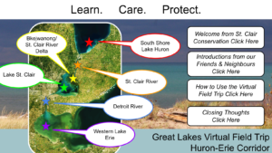
The Great Lakes play a vital role in the lives of residents who are lucky to call the Great Lakes Basin home but, for many, the importance of these significant natural features is not appreciated as much as it could be. In an effort to increase awareness of the role the Great Lakes have in our everyday lives, St. Clair Region Conservation Authority (SCRCA) created an online Virtual Field Trip for the Huron-Erie Corridor through funding provided by the Ontario Ministry of the Environment, Conservation, and Parks. The field trip engages students on the ecosystem services provided by the waters of the Huron-Erie Corridor and local threats facing their future.

Viewers are taken on a trip through the Huron-Erie Corridor from the southern shores of Lake Huron to Lake Erie. The trip features stops at the St. Clair River, Bkejwanong/Walpole Island, and the Detroit River. During their trip, participants Learn, Care, Protect, and Connect with the water through insights shared by Indigenous Water Protectors, community activists, and other individuals. Learn about the “Great Problems” faced by the Great Lakes and gain a deeper understanding of local history, geography, and actions.

The field trip is formatted in an interactive, ‘clickable’ Google Slide presentation filled with rich local content.

The St. Clair Region Conservation Authority would like to thank Essex Region Conservation Authority; Lower Thames Valley Region Conservation Authority; Lambton Shores Phragmites Community Group; Ipperwash Phrag Phighters; Aamjiwnaang First Nation; Walpole Island/Bkejwanong First Nation; Kettle and Stony Point First Nation; Detroit River Canadian Cleanup; Leamington District High School Eco-Team; and Friends of the St. Clair River for their assistance in the development of the Huron-Erie Great Lakes Virtual Field Trip.

Virtual Field Trip


The Great Lakes Virtual Field Trip Series

While the SCRCA Great Lakes Virtual Field Trip focused on the Huron-Erie Corridor, other online tools were also developed for participants to explore other regions of the Great Lakes Basin.

To visit the Great Lakes Virtual Field Trips produced as part of this project, please visit the links below:

  • Lake Superior Great Lakes Virtual Field Trip (by EcoSuperior)
  • Huron-Georgian Bay Great Lakes Virtual Field Trip (by the Nottawasaga Valley Conservation Authority)
  • Huron-Erie Corridor Great Lakes Virtual Field Trip (by the St. Clair Region Conservation Authority)
  • Ottawa and St. Lawrence River Great Lakes Virtual Field Trip (by South Nation Conservation Authority)


The Virtual Field Trips are tailored to connect to Province of Ontario science, geography, and history curriculum expectations for grades 8 to 10.

Check out our latest newsletter! Download

© 2026 · St. Clair Region Conservation Authority - The Sydenham River Watershed

  • Privacy
Prev Next

Press Enter to search · Esc to close