Introducing the Sydenham Phosphorus Reduction Initiative
April 2025 | SCRCA SPRI Team
The following blog contains information from our first SPRI Newsletter. Please click here to read more: SPRI Newsletter: Introducing SPRI
St. Clair Conservation recently secured four years of funding through the Canada Water Agency (a new, standalone branch of Environment and Climate Change Canada) to support the Sydenham Phosphorus Reduction Initiative (SPRI). The goals of SPRI are:
1. To decrease the overall non-point source phosphorus loads in the Sydenham River Watershed, as the River is the 3rd largest Canadian contributor of phosphorus to Lake Erie, and,
2. To increase the adoption and sustainability of agricultural and rural Best Management Practices (BMPs) in high phosphorus-yielding areas.

Much of the funding over the four years is directly aimed at supporting agricultural BMPs in the Sydenham River Watershed, with priority set in three sub-watersheds:
- Bear Creek Headwaters (Yellow)
- Brown Creek (Orange)
- Sydenham Headwaters (Green)
However, the light pink area indicated on the map above shows the remaining eligible area for SPRI funding.
What are the concerns?
As producers, you understand that phosphorus is a nutrient essential to life. It is found in all plants and animals as well as in their waste. Phosphorus comes in different forms, including particulate and dissolved, which together make up total phosphorus (or TP).
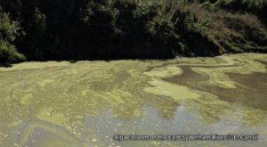
Algae are a natural part of the environment, but are limited by the amount of phosphorus present. As phosphorus becomes readily available, explosive growths of algae, known as algal blooms, can occur. Algal blooms can be toxic, pollute shorelines, and lower oxygen levels, all of which can impact the safety of water for drinking, recreation, and wildlife.
Nutrient-enriched waters from the Sydenham Watershed contribute to the severe algal blooms and low oxygen zones that occur in Lake St. Clair and further downstream in Lake Erie. Algal blooms in the Lake Erie basin can be so large that they are visible from space. To address this issue, Canada and the U.S. are working together to reduce phosphorus loads to the lake by 40% from 2008 levels.
So, why a focus on the Sydenham River?
The Sydenham River Watershed drains 3,498 km2 of land in southwestern Ontario and is part of the Lake Erie basin. Actions in the watershed impact local water quality as well as conditions downstream.
Within the Sydenham watershed, agriculture is critical to the local economy and makes up 82% of the land use. The dominant crops are soybeans (38%), corn (23%), and wheat (10%), which together account for 71% of the overall agricultural land use in the watershed.
Movement of Phosphorus
The movement of phosphorus is closely tied to the movement of water on the landscape. The greatest movement of phosphorus occurs during the non-growing season (October to April) when many soils are exposed to rain and snowmelt, flushing dissolved and particulate (sediment-bound) phosphorus off the landscape into watercourses. Using data from monthly and high-frequency sampling programs from 2012 to 2015, Environment Canada estimated that 86–91% of total phosphorus loadings to the Sydenham River occurred during runoff events.
Phosphorus sources are divided into two categories: point and non-point sources. Point sources are known sources and are easy to identify. Non-point sources are not as easily identifiable or easy to address. Water quality monitoring and scientific models that compile and analyze multiple data sources (for example, crop rotations, soils, precipitation, climate, and many more) are important for estimating the loads from non-point sources.
Point Sources: There are 18 municipal sewage treatment plants and 14 industrial wastewater treatment plants in the watershed. Together, these facilities release ~26 metric tonnes of total phosphorus every year into our watercourses through their treated effluent(1). Therefore, point sources account for approximately 11% of the annual total phosphorus load in the Sydenham River.
Non-Point Sources: Agriculture is the dominant land use in our watershed and the main non-point source of phosphorus. Runoff, whether overland or through subsurface tile drainage, contains fertilizers, pesticides, biosolids, compost, and soils and contributes ~201 metric tonnes of total phosphorus, or 89% of the phosphorus load in the Sydenham River each year1. Agricultural land in the Sydenham Watershed is predominantly flat with poorly drained soils, leading to extensive use of buried tile drainage. In fact, 77% of the agricultural land in the watershed is tile drained. Subsurface drainage contributes significantly to the transport of dissolved phosphorus to watercourses.
Solutions
There is no single solution to reducing non-point sources of excess phosphorus from reaching the aquatic environment. Adopting a range of practices that prioritize preventing, controlling, and finally capturing excess phosphorus (as well as the water that carries it) has a significant local impact. Future newsletters will highlight various practices that build soil health (prevent movement), control water within and below fields (control movement), and manage riparian areas (capture phosphorus before it enters a waterway). Learn more about Best Management Practices (BMPs),
A strong foundation of healthy soils is essential, followed by selecting practices tailored to the landscape and operation. Problem areas can also be addressed at both the watershed and field scale.